How to add your own routes in Google Maps on Android
A couple of days ago I wrote about my frustration with lack of real time tracking for public transport. I mentioned in that article that I had to trace the bus routes myself to figure out where each route goes, which I frankly shouldn’t have to do – it’s the bus company’s job. I did do it, however, and this is how.
Google Maps and Google Earth support .kmz files, which can contain both waypoints and routes. The bus company offers a .kmz file with all the bus stops in this county, which at least is something. The file contains all the stops in the entire county though, so Google Maps outright can’t load it, and Google Earth even stumbles a bit when you shove that much data into it at once – especially on a mobile device (Google Earth for Android also supports these files). What I wanted was a way to see the stops for a single bus route, along with a traced route in the color used to indicate that route in all the tables and whatnot. No one at the bus company seems to have thought of this, though.
During my quest to get this working, I got to know Google Maps and Google Earth a bit better. I’m not impressed. Both of them crashed and bugged out more times than I think I’ve seen any other Google product ever do, and I frankly don’t get why these two products are separate. Google Maps is browser based, Google Earth is not, but why can’t the latter also contain the first? It’s really annoying to have to work with two separate apps that really do much of the same.
To actually get something into Google Maps on Android, you need to add it to “My places” in Google Maps in the browser. You can do this directly in Google Maps, or import .kmz files and use those. That last option is much needed, as Google Earth generally has better tools to create routes. In Google Maps you can trace a route directly in the browser, but the system is very limited with regards to editing it afterwards compared to drawing a route in Google Earth. I therefore ended up using the Google Earth path system, which is at least a bit better. It lets you create a route by simply clicking to create waypoints, and you can also change the color and thickness of the line, as well as add various additional information. It’s not overly intuitive, as you actually need the properties dialog box open to be able to make the route. Each time you click out of it, you save, and then yo uhave to go back into its properties to edit again. The path option itself is available in the “add” menu.

While I was making these routes, I also had the file with all the bus stops loaded. I followed those to trace the route, and also added each stop to “My places” in Google Earth (not to be confused with the one in Google Maps). For each route I saved these stops out to their own file, then cleared “My places”. I also exported the routes themselves as individual .kmz files, giving me one file with the stops, one with the routes.
These files were then loaded into Google Maps and used to create a map under “My places”. This was an extremely buggy system, requiring you to import files twice to make them show up in many cases. You also can’t load too much into a single map, as it will then simply not display everything. As such, I ended up creating individual maps for each bus route. In “My places” in Google Maps I added a new map, gave it a name, and then imported both the route and the stops .kmz files.
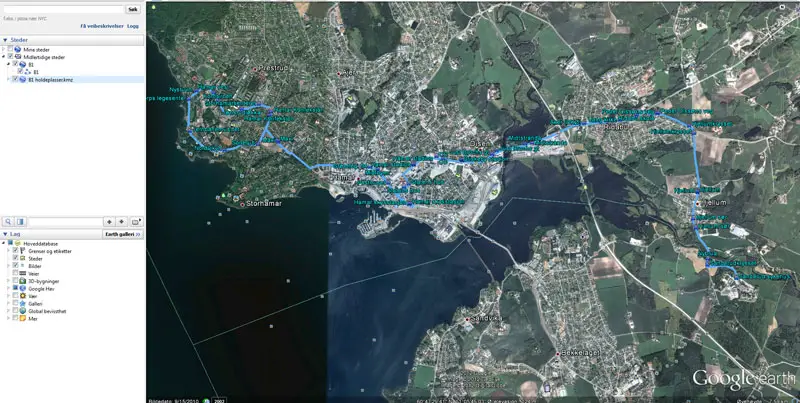
These maps then sync wirelessly, so that they’re available in Google Maps on Android the next time you log on. They’re accessible as toggleable layers, so that you can overlay them on the map. It looks something like this:

Even though I had to figure out this system from the ground up as I haven’t really used it like this before, it didn’t take me that long to get the bus routes I needed into Google Maps. I’m fairly familiar with parts of the routes, but when I now need to go somewhere out of the ordinary, I can just overlay the maps on my phone, see the routes, and which bus stop is closest. I didn’t include any schedule information as I have an app to handle that, but I actually believe it’s possible to create a time based route using this system – at least in Google Earth on a computer.
While I’m not happy with how buggy and unintuitive this system is, I’m happy that it’s there. I’m sure there are a lot of uses for something like this, and the combination of Google Maps, Google Earth, Street View, and your own routes and waypoints is a good one.